
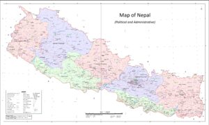
Within a short distance, Nepal’s topography changes from the alluvial Gangetic plains suitable for agriculture to the frozen wastes of the Himalayan mountains. Between the two extremes lie the middle hills and the lesser mountains consisting of the Churia range and the Mahabharat lek as they are known. There are several inner Himalayan valleys with desert conditions such as the upper Kaligandaki and Bheri valleys located at altitudes above 3,600m.
Upper Himalaya
The Upper Himalaya ranges from 4,000m above sea level to 8,848.86 m above sea level. It occupies 15% of the total area of the country and within this region lie eight of the fourteen highest peaks in the world exceeding 8000m. They are: Mount Everest, Kanchenjunga, Lhotse, Makalu, Cho Oyu, Dhaulagiri, Manaslu and Annapurna. The high Himalaya is extremely cold, windy and inhospitable while the region immediately below them are inhabited but the land is far less fertile than the lower Himalayas. Thus, cultivation is minimal in this region. However, it is the mountains that attract the bulk of tourists who arrive in Nepal for trekking and mountaineering.
Middle Hills & Lower Himalaya
The middle hills and Lower Himalaya form the largest part of the country and also has the largest population. Occupying 68% of the country, it enjoys a temperate climate and the land here is far more fertile than in the upper Himalayan region. At the high end, the Mahabharat range reaches an altitude of around 4000m above sea level while the Churia range is lower in comparison. In this region lies the capital, Kathmandu and some of the popular tourist destinations such as Pokhara and Tansen.
Tarai Region
The plains of Nepal are known as the Tarai and they occupy 17% of the land, stretching from the far-west to the far-east covering the entire southern part of the country. The lowest altitude in this region is known to be 70m above sea level. With a sub-tropical climate, the land here is exceedingly fertile and produces the bulk of the food grains for the country’s population. Along this belt lie the Chitwan National Park, Bardia National Park, Shukla Phanta Wildlife Reserve and the Koshi Tappu Wildlife Reserve which harbor an amazing variety of wildlife including endangered species such as the elusive Royal Bengal tiger, the One-horned rhinoceros and Gangetic dolphins along with rare species of birds.
Climate
Nepal experiences 4 seasons:
Spring (Mid Feb – April),
Summer (May – Aug),
Autumn (Sep – Nov) and
Winter (Dec – Mid- Feb).
The climate changes rapidly from the sub-tropical Tarai to the cool dry temperate and alpine conditions in the northern Himalayan ranges within a short span of 200 km. In the Tarai, which is the hottest part of the country, summer temperatures rise above 45°C. The climate here is hot and humid. In the middle hills, the summer climate is pleasant with temperatures around 25°C – 27°C.
The winter temperatures range from 7°C to 23°C in the Tarai and sub-zero to 12°C in the mountainous regions, hills and valleys. The northern Himalayan region has an alpine climate with temperatures reaching below -30°C. The valley of Kathmandu has a pleasant climate with an average summer and winter temperatures of 19°C – 27°C and 2°C – 12°C respectively.